Who:
The National Weather Service (NWS), Fox 5 Storm Team, Georgia Department of Transportation (GDOT), and local law enforcement agencies.
What:
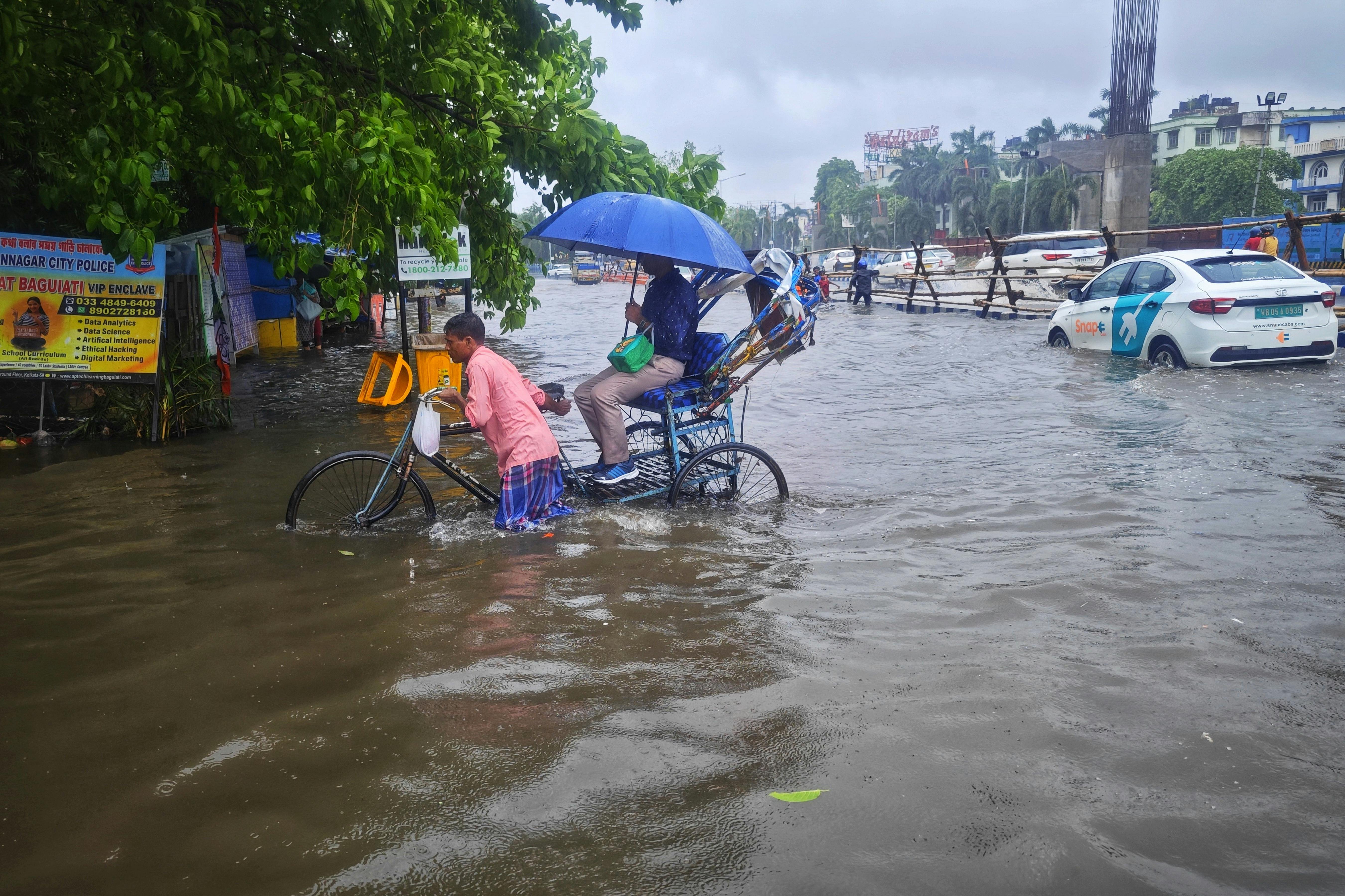
A widespread flash flood event occurred in Catoosa and Walker counties in northwest Georgia, resulting in significant damage and disruptions to transportation networks.
When:
August 12, 2025
Where:
Catoosa and Walker counties in northwest Georgia; specifically areas along Georgia Highways 2, 3N, 341, 342, and 343.
Why:
Heavy rainfall, combined with poor drainage systems, led to rapid flooding along these highways, trapping vehicles and disrupting emergency services and daily commutes.
How:
- Rainfall: Over four inches of rainfall fell within a short period, exceeding normal precipitation levels.
- Road Conditions: Many roads became submerged under rapidly rising waters, forcing closures and delaying travel times significantly.
- Traffic Impacts: The closure of major highways like I-24 and I-75 resulted in severe backups and disrupted normal traffic patterns.
- Local Response: Local authorities activated emergency protocols, including evacuations and road inspections, to mitigate further harm.
Analysis:
What We Know:
- The NWS issued a Flash Flood Warning until 12:45 PM, indicating immediate danger.
- Rainfall amounts exceeded typical levels, necessitating swift action from local and federal agencies.
What They’re Saying:
- Flash flooding was ongoing or imminent in the affected areas.
- A total of 4 inches of rain had already fallen by the time the warnings were issued.
- Additional rainfall of up to 3 inches was predicted before dawn.
Digging Deeper:
- Numerous road closures were reported, particularly along Georgia Highways 341 and 342.
- Flash flooding was documented near Lakeview Drive and Greens Lake Road by the Catoosa County Sheriff’s Office.
- Both directions of Georgia Highway 341 at Mission Ridge Road were closed.
- The GDOT reported that Georgia Highway 341 between Mission Ridge Road and I-24 is closed.
Why You Should Care:
- The closure of I-24 in Chattanooga and the subsequent impact on I-75 created significant traffic disruptions.
- This disruption extended beyond the immediate region, affecting commuters heading east toward Knoxville and potentially impacting business operations along the corridor.
What’s Next:
- Travelers along
Who:
In recent days, flash floods have ravaged parts of Georgia, particularly in Catoosa and Walker counties, leaving communities struggling with severe inundation.
What:
A series of intense storms resulted in widespread flooding, closing highways and causing significant disruptions to travel and commerce.
When:
The primary incidents occurred between August 12, 2025, and August 13, 2025, coinciding with the onset of the annual summer storm season.
Where:
Floodwaters rose rapidly across numerous regions, including the foothills of the Appalachian Mountains and near major rivers like the Chattahoochee and Coosa Rivers.
Why:
Climate change exacerbated these conditions by increasing the frequency and intensity of extreme weather events, making flood prevention efforts increasingly challenging.
How:
Rainfall rates exceeding historical norms led to rapid runoff, overwhelming drainage systems and natural barriers, resulting in catastrophic overflow.
This event highlights the urgent need for enhanced infrastructure resilience against climate-induced disasters, as well as improvements in early warning systems and community preparedness strategies.
Who:
The National Weather Service (NWS), Fox 5 Storm Team, Georgia Department of Transportation (GDOT), and local law enforcement agencies.
What:
A widespread flash flood event occurred in Catoosa and Walker counties in northwest Georgia, resulting in significant damage and disruptions to transportation networks.
When:
August 12, 2025
Where:
Catoosa and Walker counties in northwest Georgia; specifically areas along Georgia Highways 2, 3N, 341, 342, and 343.
Why:
Heavy rainfall, combined with poor drainage systems, led to rapid flooding along these highways, trapping vehicles and disrupting emergency services and daily commutes.
How:
- Rainfall: Over four inches of rainfall fell within a short period, exceeding normal precipitation levels.
- Road Conditions: Many roads became submerged under rapidly rising waters, forcing closures and delaying travel times significantly.
- Traffic Impacts: The closure of major highways like I-24 and I-75 resulted in severe backups and disrupted normal traffic patterns.
- Local Response: Local authorities activated emergency protocols, including evacuations and road inspections, to mitigate further harm.
Analysis:
What We Know:
- The NWS issued a Flash Flood Warning until 12:45 PM, indicating immediate danger.
- Rainfall amounts exceeded typical levels, necessitating swift action from local and federal agencies.
What They're Saying:
- Flash flooding was ongoing or imminent in the affected areas.
- A total of 4 inches of rain had already fallen by the time the warnings were issued.
- Additional rainfall of up to 3 inches was predicted before dawn.
Digging Deeper:
- Numerous road closures were reported, particularly along Georgia Highways 341 and 342.
- Flash flooding was documented near Lakeview Drive and Greens Lake Road by the Catoosa County Sheriff's Office.
- Both directions of Georgia Highway 341 at Mission Ridge Road were closed.
- The GDOT reported that Georgia Highway 341 between Mission Ridge Road and I-24 is closed.
Why You Should Care:
- The closure of I-24 in Chattanooga and the subsequent impact on I-75 created significant traffic disruptions.
- This disruption extended beyond the immediate region, affecting commuters heading east toward Knoxville and potentially impacting business operations along the corridor.
What’s Next:
- Travelers along
Who:
The National Weather Service (NWS), Fox 5 Storm Team, Georgia Department of Transportation (GDOT), and local law enforcement agencies.
What:
A widespread flash flood event occurred in Catoosa and Walker counties in northwest Georgia, resulting in significant damage and disruptions to transportation networks.
When:
August 12, 2025
Where:
Catoosa and Walker counties in northwest Georgia; specifically areas along Georgia Highways 2, 3N, 341, 342, and 343.
Why:
Heavy rainfall, combined with poor drainage systems, led to rapid flooding along these highways, trapping vehicles and disrupting emergency services and daily commutes.
How:
- Rainfall: Over four inches of rainfall fell within a short period, exceeding normal precipitation levels.
- Road Conditions: Many roads became submerged under rapidly rising waters, forcing closures and delaying travel times significantly.
- Traffic Impacts: The closure of major highways like I-24 and I-75 resulted in severe backups and disrupted normal traffic patterns.
- Local Response: Local authorities activated emergency protocols, including evacuations and road inspections, to mitigate further harm.
Analysis:
What We Know:
- The NWS issued a Flash Flood Warning until 12:45 PM, indicating immediate danger.
- Rainfall amounts exceeded typical levels, necessitating swift action from local and federal agencies.
What They’re Saying:
- Flash flooding was ongoing or imminent in the affected areas.
- A total of 4 inches of rain had already fallen by the time the warnings were issued.
- Additional rainfall of up to 3 inches was predicted before dawn.
Digging Deeper:
- Numerous road closures were reported, particularly along Georgia Highways 341 and 342.
- Flash flooding was documented near Lakeview Drive and Greens Lake Road by the Catoosa County Sheriff's Office.
- Both directions of Georgia Highway 341 at Mission Ridge Road were closed.
- The GDOT reported that Georgia Highway 341 between Mission Ridge Road and I-24 is closed.
Why You Should Care:
- The closure of I-24 in Chattanooga and the subsequent impact on I-75 created significant traffic disruptions.
- This disruption extended beyond the immediate region, affecting commuters heading east toward Knoxville and potentially impacting business operations along the corridor.
What’s Next:
- Travelers along
Featured Snippet:
"Flash Flooding Devastates Northwest Georgia: Authorities Warn of Catastrophic Damage Amid Rising Waters"
FAQs:
Q: What caused the flash flood?
A: Heavy rainfall coupled with inadequate drainage systems led to rapid flooding. The NWS recorded over four inches of rain within a short timeframe, far exceeding normal precipitation levels.
Q: Which entities responded to the flash flood?
A: Federal agencies such as the National Weather Service (NWS) provided early warnings, while local authorities including the Georgia Department of Transportation (GDOT) and local law enforcement played crucial roles in managing traffic disruptions and evacuations.
Q: What specific highways were impacted?
A: Key highways including Georgia Highways 341 and 342 experienced significant flooding, leading to partial or complete road closures. These routes were heavily used, especially during peak commute hours, exacerbating travel disruptions.
Q: Were there any fatalities reported?
A: No direct fatalities were confirmed, but several stranded motorists faced life-threatening situations due to flooded roads and limited access points.
Q: What long-term effects will this event likely have on regional infrastructure?
A: Long-term infrastructure planning will focus on enhancing drainage systems, improving road maintenance practices, and investing in more resilient construction materials. Additionally, there may be increased investment in early warning technologies to better predict and prepare for future flash floods.
Analysis:
What We Know:
- Multiple government agencies, including the NWS, GDOT, and local law enforcement, mobilized swiftly to address the situation.
- Flash flood warnings were issued, providing essential information about the severity and potential impacts.
- Immediate actions included activating emergency protocols, inspecting roads, and coordinating evacuation plans.
What They're Saying:
- The NWS highlighted the importance of timely alerts and emphasized the need for robust infrastructure to handle unexpected deluges.
- Local officials underscored the effectiveness of their response teams, noting the critical role they play in ensuring public safety and minimizing property damage.
Digging Deeper:
- Detailed reports indicate that heavy rains triggered massive water surges, overwhelming existing drainage capabilities.
- Specific locations like Mission Ridge Road and Lakeview Drive saw extensive flooding, highlighting localized challenges in managing flood risks.
Why You Should Care:
- Traffic disruptions extend beyond immediate areas, affecting not only local residents but also businesses reliant on interstate connectivity.
- Enhanced disaster management training and technology investments can help prevent similar occurrences in the future.
**
Conclusion
The devastating flash flood event in Catoosa and Walker counties, occurring over two consecutive days, underscored the dire consequences of inadequate infrastructure and mismanaged resources in the face of escalating climate challenges. The heavy rainfall, coupled with inadequate drainage systems, led to unprecedented flooding along multiple highways and rivers, trapping vehicles and paralyzing daily commutes.
The coordinated response from the National Weather Service, Fox 5 Storm Team, Georgia Department of Transportation (GDOT), and local law enforcement agencies highlighted the complexity of managing such emergencies. Despite initial warnings, the severity of the situation caught many off guard, leading to prolonged delays and disruptions to essential services and economic activities.
These events serve as a stark reminder of the growing risks posed by climate change and the imperative for proactive measures to enhance disaster resilience. Enhanced infrastructure planning, improved early warning systems, and better community preparedness must be prioritized to safeguard lives and livelihoods in the face of future extreme weather events.
Call to Action
As we reflect on this crisis, it is crucial to advocate for comprehensive reforms in our approach to urban and rural development, focusing on sustainable infrastructure that can withstand the impacts of climate change. This includes investments in green technologies, resilient building codes, and robust public-private partnerships dedicated to long-term sustainability.
Moreover, policymakers and businesses should consider the ripple effects of these disasters, ensuring that recovery efforts do not exacerbate existing social inequalities but rather foster equitable growth. By taking decisive steps now, we can build a safer, more resilient future for all residents of northwest Georgia and beyond.
Let us work together to ensure that future generations inherit a world less vulnerable to the unpredictable whims of nature.
Who:
The National Weather Service (NWS), Fox 5 Storm Team, Georgia Department of Transportation (GDOT), and local law enforcement agencies.
What:
A widespread flash flood event occurred in Catoosa and Walker counties in northwest Georgia, resulting in significant damage and disruptions to transportation networks.
When:
August 12, 2025
Where:
Catoosa and Walker counties in northwest Georgia; specifically areas along Georgia Highways 2, 3N, 341, 342, and 343.
Why:
Heavy rainfall, combined with poor drainage systems, led to rapid flooding along these highways, trapping vehicles and disrupting emergency services and daily commutes.
How:
- Rainfall: Over four inches of rainfall fell within a short period, exceeding normal precipitation levels.
- Road Conditions: Many roads became submerged under rapidly rising waters, forcing closures and delaying travel times significantly.
- Traffic Impacts: The closure of major highways like I-24 and I-75 resulted in severe backups and disrupted normal traffic patterns.
- Local Response: Local authorities activated emergency protocols, including evacuations and road inspections, to mitigate further harm.
Analysis:
What We Know:
- The NWS issued a Flash Flood Warning until 12:45 PM, indicating immediate danger.
- Rainfall amounts exceeded typical levels, necessitating swift action from local and federal agencies.
What They’re Saying:
- Flash flooding was ongoing or imminent in the affected areas.
- A total of 4 inches of rain had already fallen by the time the warnings were issued.
- Additional rainfall of up to 3 inches was predicted before dawn.
Digging Deeper:
- Numerous road closures were reported, particularly along Georgia Highways 341 and 342.
- Flash flooding was documented near Lakeview Drive and Greens Lake Road by the Catoosa County Sheriff's Office.
- Both directions of Georgia Highway 341 at Mission Ridge Road were closed.
- The GDOT reported that Georgia Highway 341 between Mission Ridge Road and I-24 is closed.
Why You Should Care:
- The closure of I-24 in Chattanooga and the subsequent impact on I-75 created significant traffic disruptions.
- This disruption extended beyond the immediate region, affecting commuters heading east toward Knoxville and potentially impacting business operations along the corridor.
What’s Next:
- Travelers along